


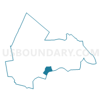
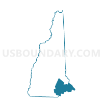
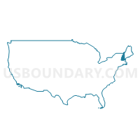
TOWN OF NEWTON Voting District, Rockingham County, New Hampshire
About
Outline

Summary
| Unique Area Identifier | 616422 |
| Name | TOWN OF NEWTON Voting District |
| County | Rockingham County |
| State | New Hampshire |
| Area (square miles) | 10.06 |
| Land Area (square miles) | 9.91 |
| Water Area (square miles) | 0.15 |
| % of Land Area | 98.49 |
| % of Water Area | 1.51 |
| Latitude of the Internal Point | 42.87036940 |
| Longtitude of the Internal Point | -71.04591510 |
Maps
Graphs
Select a template below for downloading or customizing gragh for TOWN OF NEWTON Voting District, Rockingham County, New Hampshire


Neighbors
Neighoring Voting District (by Name) Neighboring Voting District on the Map
- Amesbury Precinct 5, Essex County, MA
- Haverhill Ward 4 Precinct 2, Essex County, MA
- Merrimac Precinct 1, Essex County, MA
- TOWN OF EAST KINGSTON Voting District, Rockingham County, NH
- TOWN OF KINGSTON Voting District, Rockingham County, NH
- TOWN OF PLAISTOW Voting District, Rockingham County, NH
- TOWN OF SOUTH HAMPTON Voting District, Rockingham County, NH
Top 10 Neighboring County Subdivision (by Population) Neighboring County Subdivision on the Map
- Haverhill city, Essex County, MA (60,879)
- Amesbury Town city, Essex County, MA (16,283)
- Plaistow town, Rockingham County, NH (7,609)
- Merrimac town, Essex County, MA (6,338)
- Kingston town, Rockingham County, NH (6,025)
- Newton town, Rockingham County, NH (4,603)
- East Kingston town, Rockingham County, NH (2,357)
- South Hampton town, Rockingham County, NH (814)
Top 10 Neighboring Place (by Population) Neighboring Place on the Map
Top 10 Neighboring Elementary School District (by Population) Neighboring Elementary School District on the Map
Top 10 Neighboring Secondary School District (by Population) Neighboring Secondary School District on the Map
Top 10 Neighboring Unified School District (by Population) Neighboring Unified School District on the Map
- Haverhill School District, MA (60,879)
- Timberlane Regional School District, NH (24,733)
- Pentucket School District, MA (17,032)
- Amesbury School District, MA (16,283)
- Sanborn Regional School District, NH (10,628)
Top 10 Neighboring State Legislative District Lower Chamber (by Population) Neighboring State Legislative District Lower Chamber on the Map
- Second Essex District, MA (42,019)
- First Essex District, MA (41,982)
- Third Essex District, MA (41,038)
- State House District 8, Rockingham County, NH (22,157)
- State House District 14, Rockingham County, NH (13,867)
- State House District 11, Rockingham County, NH (6,960)
Top 10 Neighboring State Legislative District Upper Chamber (by Population) Neighboring State Legislative District Upper Chamber on the Map
- First Essex District, MA (170,805)
- State Senate District 23, NH (56,793)
- State Senate District 22, NH (56,033)
Top 10 Neighboring 111th Congressional District (by Population) Neighboring 111th Congressional District on the Map
- Congressional District 5, MA (662,269)
- Congressional District 1, NH (657,984)
- Congressional District 6, MA (650,161)
Top 10 Neighboring Census Tract (by Population) Neighboring Census Tract on the Map
- Census Tract 1011, Rockingham County, NH (7,609)
- Census Tract 2621, Essex County, MA (6,338)
- Census Tract 1051, Rockingham County, NH (6,025)
- Census Tract 1021, Rockingham County, NH (4,603)
- Census Tract 2661, Essex County, MA (4,032)
- Census Tract 2603.02, Essex County, MA (3,091)
- Census Tract 625, Rockingham County, NH (2,938)
- Census Tract 620, Rockingham County, NH (2,357)
Top 10 Neighboring 5-Digit ZIP Code Tabulation Area (by Population) Neighboring 5-Digit ZIP Code Tabulation Area on the Map
- 01830, MA (25,137)
- 01913, MA (16,283)
- 03865, NH (7,609)
- 01860, MA (6,338)
- 03848, NH (6,020)
- 03858, NH (4,603)
- 03827, NH (3,150)